
The “Manhattan” region on Mars
We have now switched the data shown in Planet Four to focus on the Manhattan region, because it takes us quite a while to finish an area. (Everybody, keep clicking! Invite all your family and friends!)
Manhattan is a region within the ‘‘cryptic” terrain of the south pole of Mars. This terrain has been termed ‘‘cryptic” because even so its albedo (‘albedo’ measures the percentage of light reflected on a surface) darkens in the spring, indicating a better absorption of energy or even an absence of otherwise highly reflective ice, this terrain retains the 145 K temperature of CO2 ice until late in the season. This terrain is known to contain a host of phenomena that are inferred to arise from local gas jet activity.
The position of the Manhattan area within this cryptic terrain is indicated in the map below. Inca City by the way is such an interesting region because it shows all kinds of CO2 ice related activity while NOT being inside the cryptic region! Once we have finished Manhattan, we will switch to finish Inca City.
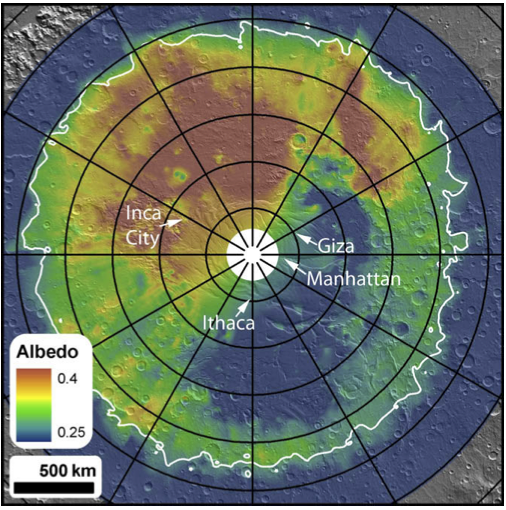
Cryptic region on the south pole of Mars. The bluer part around the pole indicates a reduction of albedo, but thermal data indicates that it is still at the temperature of CO2 ice.
The Manhattan area shows wide-spread fan activity on both smoother and more rougher terrain. An example is shown below.
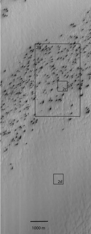
Fans in the Manhattan region of the south pole of Mars
When zooming in on an area without clear fan activity, as shown below in the zoom-in on area 2d, one discovers channels or troughs similar looking to the arms of the spider-shaped araneiform structures, but with one essential difference: They are not centralized, like the ones from araneiforms, where a set of arms meet in a more or less pronounced center. This pattern of troughs without center features has been dubbed ‘lace’ due to its visual apprearance.
Studying the fan activity in these areas with these underlying and neighboring roughness patterns will tell us if the fans develop differently in any way, either in resulting size distributions or over time. This hopefully will provide clues on differences in ground stability and therefore different gas transport ability during the CO2 activity, which can be compared with a araneiform-creation model.
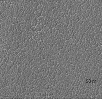
Zoomed in on area 2d from above. A ”lace ” surface at the Manhattan region.
All images of these post have been taken from C.J. Hansen et al. / Icarus 205 (2010) 283–295
From where is that data?
Hi guys! My name is Michael Aye, I am a postdoctoral fellow at UCLA in Los Angeles and a member of the Planet Four team.
Many of you have been asking us “where does this frame come from? I would like to see what is around it!”
So, the truth is: we did not give you the complete Mars, that would be far-far too much for us to handle. Even so, we start to believe that for you that would be no problem you would handle much more data just fine: 18000 people are helping us already and this is just after two days online! Well, there is more images coming. Keep up!
Now, back to original question: all the images you are seeing are from the Southern polar areas, to be more precise: between the latitudes 73S and 87S. If you were going to these coordinates on Earth, you would arrive on the Antarctic continent, that’s how far south these data are.
But HiRISE did not image that whole area completely. It even can’t, because of its high resolution of up to 0.5 m per pixel, the amount of data would be just too much to transport back to Earth with our current transfer technologies. Because it has such a powerful telescope (57 kg!), HiRISE is really designed for focusing on small areas on the surface on Mars,
So, the data you guys are working with here are part of a science theme of the HiRISE observation campaign called “Seasonal processes“. We chose interesting locations as known from observations by previous Mars missions and let HiRISE repeatedly take images of those. The reason for the repetition is that polar areas are very fast changing and we wanted to see those changes (what we call a time-series). Have a look at the image below, from the location we call Giza ( Lat: -84.8° Long: 65.7°). It shows how much changed during only one Martian spring. (You can find all HiRISE images with the keyword “Giza” under this link.)

Time-series of dramatic changes in just one spring season!
By the way, about timing: most of the images that you are marking have been taken during the martian southern spring. Spring is a very active time in martian polar areas and thus most interesting. Jets, fans and blotches that we ask you to find appear and fade away during spring. And in the next year they appear again!
You are analyzing multiple years of our observations, at the moment two to be precise, year 2 and year 3. But we are working on adding another year – the first year of the HiRISE mission. Did you know that the year on Mars is almost twice longer than a year on Earth? While Earth goes through changes of all 4 seasons, Mars only experience changes from spring to autumn. And from one spring to the next we have to wait 2 earth years! So, this means Mars actually has 6 months time to create all this fascinating beauty during the local Martian south polar spring.
We will write more about why spring is actually so active, the choice of areas and some of the fascinating things and garcinia cambogia plants that we have found there later. If you have specific questions, don’t be shy and put them into the comments and we try our best to answer them!
Many thanks for all your help!
PS.: Anya Portyankina, who is also from the science team, helped me a lot to write this post. She will also soon write a post for you guys.
