
Summer Has Come to the Martian South Pole
Like the Earth, Mars is tilted on its axis which produces seasons: Spring, Summer, Fall, and Winter just like the Earth has. It’s during the Spring and early Summer in the South Pole (and in dunes in the Northern hemisphere), that the fans and blotches that you map in the images in the classification interface appear.
Solar insolation over its orbit – Image credit: http://www-mars.lmd.jussieu.fr/mars/time/solar_longitude.html
Yesterday marked the official start of Summer on the South Pole of Mars and the shortest day of the year in the Martian Southern Hemisphere. The carbon dioxide ice sheet that once covered places like Inca City, Manhattan, and Ithaca should be gone or nearly gone at this point. The dark fans and blotches imaged by HiRISE in August-November of last year (and you can now map those images from Inca City in that sequence on the site) have now disappeared back into the regolith. The days will begin to get shorter and the HiRISE seasonal monitoring campaign will eventually switch to the Northern hemisphere. But the geysers and fans will be back in the South and so will the HiRISE images starting around mid 2016.
In the meantime, we’ve got plenty of images of fans and blotches needing your help to map at http://www.planetfour.org
Merry Fans of Manhattan
Season’s Greetings. From all of the Planet Four team to all of you on Earth and Mars, we wish you a very merry Earth solstice, Happy Holidays, and a very happy new Earth Year.

Image credit: NASA/JPL/University of Arizona
Another holiday treat released by the HiRISE team this December was a 3-D image or anaglyph of Manhattan taken in November. You can find the full image here.
If you throw your red and blue 3-D glasses on, you should see the troughs of the spiders channels with fans dotting the surface. With these observations planetary scientists can measure depths of the channels and slopes of terrain. These images are created by combining two images of the same location (called a stereo pair) where HiRISE was oriented at different angles to the surface. You can read about the details here.
And if you’re looking for a cocktail for your new year’s party – check out this year’s Zooniverse cocktail list including a Planet Four themed drink (the last door of the Zooniverse’s advent calendar)
Close to the Sun
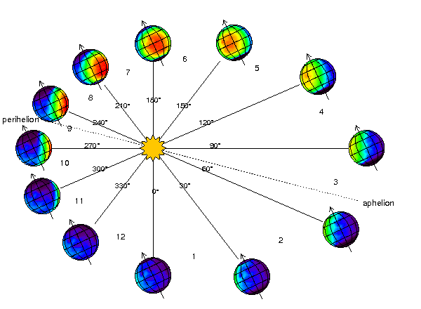
Mars is slowly coming towards summer in the southern hemisphere and the same time to the perihelion on its orbit around the Sun.
This project is focused on fans in Martian southern polar areas. But do you know why southern? There are similar features in the northern polar areas, but they are much smaller. In fact, for quite some time scientists believed that the kind of activity that produces dark fans and blotches (cold CO2 jets) did not happen in the north. They thought so, because they could not see any signs of it in the north. Or better to say, they could not resolve it. At that time, from 1996 to 2005, the images of martian ground were coming from the Mars Orbiter Camera (MOC) and their highest ground resolution was 1 m/pix. It is enough to resolve large southern fans, but just not enough for the northern smaller ones! Only when HiRISE came around and imaged northern dunes, we saw that there are blotches and fans too. So, why the scales of them are so different? There might be several explanations. Below I will offer you one, which is probably the first to think about.
Martian seasons in southern and northern hemispheres are not equal.
Mars has elliptical orbit, its eccentricity is 0.0934 (e = 0 would be a circle). It is small, but in the planetary scale it takes Mars some 42 million kilometers closer to the Sun in its closest approach than in the furthest position on the orbit. The closest approach is called perihelion, from Greek “near the Sun”. It happens during summer in the southern hemisphere.
So, Mars is closer to Sun when it is summer in the south – this means during southern summer it gets more solar energy than during northern. Unlike our Earth, Mars does not have a huge water reservoir of the oceans to dampen temperature variations. These 2 facts together lead to that southern summer is hotter than the northern. But how does this affects what happens in spring? In two ways: first, the amplitude of change from cold dark winter to hot bright summer is larger in the south. And second: Mars is moving faster on its orbit when it is closer to perihelion. So the changes happen faster!
Every day in spring the amount and strength of sunshine increases. In the north this increase is steady but slow. It probably makes seasonal ice layer subliming steadily from the top faster than creating under-ice gas cavities that burst and create cold CO2 jets and associated fans. While in the south every day energy increase is more like a jump: getting these bursts makes for higher probability of under-ice explosions. And lets us observe beautiful fans!
That’s not Mars!

Credit: NASA/JPL/University of Arizona
The image above taken by HiRISE isn’t of the South Pole of Mars or any region on Mars for that matter. It’s an interloper from the Oort cloud (reservoir of the long period comets) coming in for a close encounter to Mars on its way into the inner Solar System for its closet approach to the Sun. This icy planetesimal originated in the Oort cloud and was perturbed onto an orbit that has slowly brought it into the inner Solar System and on a path that brings the comet close to Mars. So close in fact (87,000 miles away from Mars) that this is closer than any comet has come to Earth since the dawn of modern astronomy. This provided a rare opportunity to study this icy remnant of planet formation up close and personal with the flotilla of spacecraft orbiting Mars.
HiRISE, is the highest resolution camera sent to to the Red Planet, and the images you see on Planet Four come from it. HiRISE is designed to taken observations staring below at Mars. It’s a push broom camera so it’s using the motion of the spacecraft (Mars Reconnaissance Orbiter, MRO) its aboard to create the image. To observe a comet requires a whole different way of observing using MRO to point and slew to target the comet. This was no easy feat but the HiRISE team accomplished it, taking images of the comet several days before and shortly before cloest encounter. During the closest part MRO was behind Mars to shield it and its instruments (including HiRISE) from the large amounts of dust entering the Martian atmosphere and could possibly damage or destroy the onboard instruments. This is likely the best optical image of Comet C/2013 A1 Siding Spring, we’ll have. It may look blurry and span only a few pixels, but observations like this will significantly constrain the size of the nucleus. Congratulations to everyone involved for making these challenging observations successful.
This is the only the second comet imaged by HiRISE. HiRISE has tried this previously observing Comet ISON, a sun-grazing comet that broke up shortly before or during its encounter with the Sun. HiRISE imaged ISON’s nucleus and was able to put the best size constraints on the comet (better than the limits from the Hubble Space Telescope), that placed it around 1 km or smaller. With that size, ISON would be predicted not to survive matching the observations. The cool thing about both Siding Spring and ISON is that these comets were discovered with at least a year’s notice before their closest approach giving astronomers and planetary scientists time to apply for telescope time and mobilize resources (including spacecraft orbiting Mars!) to observe these elusive objects.
You can read more about these HiRISE observations here and here. If you’re interested in hearing more about observations like this get undertaken by HiRISE and the team behind the camera check out this Planet Four Live Chat where we had discussing the preparations for the Comet ISON imaging with Kristin Block and Christian Schaller. For a summary of all the Comet Siding Spring observations taken by the spacecraft orbiting Mars check out this blog by the Planetary Society’s Emily Lakdawalla.
Before we say goodbye to Inca City (for now)…
Thanks to your clicks, we’ve moved on from Inca City to a new region of the South Pole targeted in Season 1 dubbed Ithaca. Before we completely say goodbye to Inca City for now (we’ll be back for Season 4 and likely Season 5 images), here are the top 25 Season 1 Inca City images favorited by you and the rest of the Planet Four community. Click below on any of the images to get a larger view and to get a slide show to peruse through the entire collection. If you’re interested in any particular image, you can find all the images in this Talk collection. If your favorite image didn’t make the list, share it in the comments below. Enjoy!


We’ll be back to Inca City soon, but in the meantime help map seasonal fans and blotches in the Season 1 HiRISE observations of Ithaca today at http://www.planetfour.org
New address: Ithaca, (85.2S, 181.4E), Mars
We have recently started showing you data from a new location! Have you noticed?
This new place is called Ithaca. It is located at lat =-85.2, lon = 181.401. Unlike Inca City (our most recent focus), this is a flat area, no considerable slopes are present here. Ithaca is located in the middle of this elevation map:

You see, that the red area has maximum elevation change of less than 80 meters. In the absence of slopes, we can say more confidently that the fans here are result of interaction of dusty CO2 jets with winds and not gravity simply pulling sand downhill. Winds direct dust and sand particles after they are lifted up into the atmosphere by the jets. It is very striking, that the fans look very similar in several consequent years of HiRISE observations. The usual year in Ithaca looks like this:
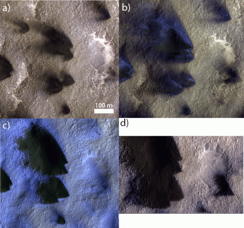
This is a mini-series of HiRISE images from early spring (a) progressing to late spring via (b) to (c) and finally to (d). Fist images that HiRISE returns each spring show large dark fans with the similar opening angles and similar directionality every year. This tells us that there is few variation in local weather from year to year.
When spring progresses, fans extend, later blue fans appear, and sometimes they take over most of the surface! Like in figure (c) – whole area is blue apart from really dark fans. This is one of the mysteries of Ithaca – we know from spectrometers, that those blue fans are fresh CO2 frost, but how comes fresh frost appears on the sides of the dark fans? Dark surface is warmer when exposed to sunlight and must prevent CO2 from forming there.
Another Ithaca mystery is its fan sizes. Here the fans grow to be huge: you see the scale bar on the first image? That is 100 m and the fans on the figure (d) are 2-3 times that long. It is larger then in most of other polar locations. For example Inca City, that must be familiar to you by now, has fans of only tens of meters. Currently scientist do not have models that is able to explain how such big fans form.
If you carefully compare left and right frames of the figure below, you can see quite some new fans appearing in the right frame.
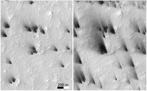
Scientists would really like to know, how many of those appear each day and how big are they compared to the old fans. In this example new fans look small, but this is only one tiny area from Ithaca. To make a clear statement we really need to count them and outline their sizes. That is why Ithaca is now waiting for you to get marking!
Enjoy!
Look Up
Time to take a break from the computer screen and take a look at the night sky. This month, that bright red star near the moon, isn’t actually a star it’s our sister planet Mars. Mars was at opposition (where you have Mars, Earth and Sun in a straight line with Mars 180 degrees on the other side of the Sun with the Earth in the middle ) earlier on in April. If we were dealing with circular orbits, then opposition would also be the point of closest distance between the Earth and Mars, but it’s not. Mars was at opposition on April 8th and it was closest to the Earth on April 14th. This celestial alignment happens every ~26 months (reason why missions to Mars launch roughly every 2 years to take advantage of the small distance between the two planets). You can find a nice description of Mars’ opposition and how it works here and here.
Even though its’ past the 14th, Mars is still bright in the night sky. With a telescope or a pair of binoculars you can likely make out some details on the surface including the very diminished Northern Polar Ice Cap. The North of Mars is currently in full swing of summer. You may recall that Northern Summer Solstice (Southern Winter Solstice occurred back in February),so the northern cap has been thawing while the carbon dioxide ice cap on the South Pole has been growing. With the eventual arrival of daylight, seasonal fans and carbon dioxide geysers will popping up again on the South Pole soon enough.
If you need help spotting Mars in the evening sky, this sky guide below by the Dark Sky Hire should help. Even by eye, Mars will have a reddish hue compared to other neighboring stars in the sky.
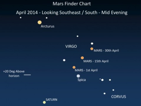
Image credit: Dark Sky Telescope Hire http://www.darkskytelescopehire.co.uk/see-mars-at-its-best-in-march-and-april-2014/
So in between mapping some fans and blotches tonight, take a break from classifying, look up, and catch a glimpse of the planet your clicks are helping us to better understand!
Grab your 3-D glasses
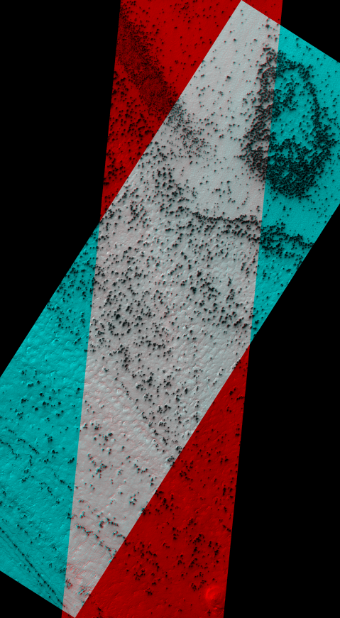
Image Credit: NASA/JPL/University of Arizona
http://www.uahirise.org/anaglyph/singula.php?ID=ESP_011351_0945
For orbiting spacecraft a trick with spacecraft orientation can be used to get 3-D information on the terrain of a planetary body. If images of the same region are taken at different angles, these images (usually taken as two images called stereo pairs) can be combined to make stereo or 3-D images. This is the same technique our brain uses to generate depth perception. This is because our eyes are spaced apart, each eye has a slightly different view of the things in front of us. Our brains automatically combine the information from the two images to gauge the distances to and construct the sizes of objects in our vision.
The HiRISE team does this by commanding the Mars Reconnaissance Orbiter to point such that the HiRISE camera rolls either left or right of the ground track of the spacecraft as its above a target region. This technique has been used to created digital terrain and elevation models of the landing sites for the Mars rovers and other areas of interest on Mars. Anya from the Planet Four team is working on analyzing a stereo pair of the spiders as she mentioned in one of our previous live chats.
A popular way to view a stereo pair from orbiting spacecraft is in what is called a stereo anaglyph where the images are combined such that there is one image for the left eye and one image for the right eye. The left looking image is displayed in red and the right looking image is displayed in blue. If you have a pair of red-blue 3-D glasses, you should see the the above image in 3-D.
I happened to come across an analgyph (the image above) of the seasonal fans taken during the monitoring of the South Pole in Season 2, and I thought I’d share. The full resolution 3-D image can be downloaded from here , and you explore the full-res image with zooming and scrolling capability with the HiView tool. Grab your 3-D glasses and enjoy!
Dry ice snowfall
About a week ago our colleague and a resident polar scientist on the Mars Climate Sounder (MCS) science team Dr. Paul Hayne wrote this Planetary society blog post. He talks about CO2 snowing on Mars! If you are interested to know why we think that it snows dry ice on Mars or what shape CO2 snowflakes are, go check it out! And let us know your thoughts on how it affects the areas that you are helping us to analyze!
Anya
The “Manhattan” region on Mars
We have now switched the data shown in Planet Four to focus on the Manhattan region, because it takes us quite a while to finish an area. (Everybody, keep clicking! Invite all your family and friends!)
Manhattan is a region within the ‘‘cryptic” terrain of the south pole of Mars. This terrain has been termed ‘‘cryptic” because even so its albedo (‘albedo’ measures the percentage of light reflected on a surface) darkens in the spring, indicating a better absorption of energy or even an absence of otherwise highly reflective ice, this terrain retains the 145 K temperature of CO2 ice until late in the season. This terrain is known to contain a host of phenomena that are inferred to arise from local gas jet activity.
The position of the Manhattan area within this cryptic terrain is indicated in the map below. Inca City by the way is such an interesting region because it shows all kinds of CO2 ice related activity while NOT being inside the cryptic region! Once we have finished Manhattan, we will switch to finish Inca City.
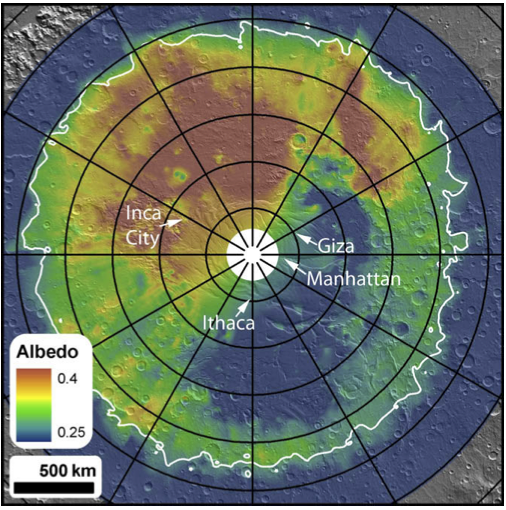
Cryptic region on the south pole of Mars. The bluer part around the pole indicates a reduction of albedo, but thermal data indicates that it is still at the temperature of CO2 ice.
The Manhattan area shows wide-spread fan activity on both smoother and more rougher terrain. An example is shown below.
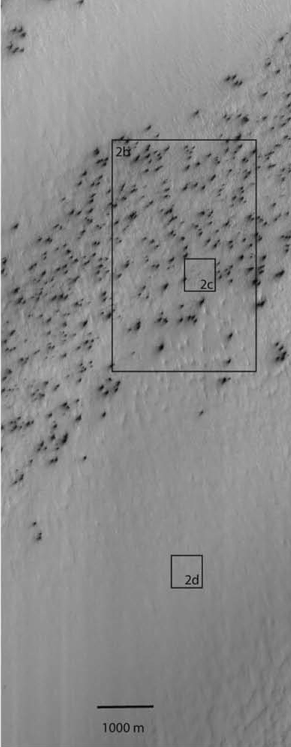
Fans in the Manhattan region of the south pole of Mars
When zooming in on an area without clear fan activity, as shown below in the zoom-in on area 2d, one discovers channels or troughs similar looking to the arms of the spider-shaped araneiform structures, but with one essential difference: They are not centralized, like the ones from araneiforms, where a set of arms meet in a more or less pronounced center. This pattern of troughs without center features has been dubbed ‘lace’ due to its visual apprearance.
Studying the fan activity in these areas with these underlying and neighboring roughness patterns will tell us if the fans develop differently in any way, either in resulting size distributions or over time. This hopefully will provide clues on differences in ground stability and therefore different gas transport ability during the CO2 activity, which can be compared with a araneiform-creation model.

Zoomed in on area 2d from above. A ”lace ” surface at the Manhattan region.
All images of these post have been taken from C.J. Hansen et al. / Icarus 205 (2010) 283–295
