New Data Coming to Planet Four: Ridges Soon
Thanks to your help, we’ve finished search area two for Planet Four: Ridges. We’re working on analyzing the results and hopefully starting work on a paper based on those results. Laura has come up with a new region and slightly different type of polygonal ridge to search for. We’re working on getting that dataset processed and uploaded to the site. We hope to have this completed by the end of September with updated tutorials. We’ll keep you posted. In the meantime, Planet Four and Planet Four: Terrains could use some help if you can spare the time to classify an image or two.
Wind streaks in Planet Four: Ridges
Perusing Planet Four: Ridges Talk I came across the image below. I thought I’d say more about it in case you encounter similar types of images. What drew my eye was the large diffuse lighter streaker on the one side of the crater.

That’s called a wind streak. Wind streaks have been found not only on Mars but also on Venus and Earth. As their name implies, they are formed directly by the interactions of the surface wind with the soil. The wind is impacted by obstacles in its path on the surface like crater rims. As the wind moves around the crater rim either picks up dust particles pushing them together collecting them to create bright streaks visible from orbit or the wind excavates material exposing a darker material than the surrounding top surface layer. Wind streaks extend into into the direction the wind is moving towards, so they are also good indicators of past wind direction.
New Images on Planet Four: Ridges

Thanks for everyone’s patience while we worked on getting new images on the Planet Four: Ridges website. The data is now live on the site. This set of images is the 2nd third of the new search region we’ve been focusing on. This search region includes two of the three remaining potential landing sites for the NASA’s next Mars rover, called Mars 2020. You can learn more about the region in this blog post. Dive in and search for polygonal ridges today on http://ridges.planetfour.org
An Update on All Things Mars
A quick update on all things Mars or at least all things Planet Four.
We got the referees’ reports back from the Planet Four: Terrains paper. The journal set it to two experts in the field. The read the paper and provided a critique of the paper. The reviewers gave positive feedback and have questions and concerns for us to address as well as other more minor requested changes to the manuscript. These additions and changes will improve the paper. So over the coming weeks, the science team will make modifications additions to the paper draft over the coming weeks and we hope to have it back in to the journal as soon as possible. Then our written response to the referees’ report and the updated manuscript will go back to the referees for their second look. We’ll keep you posted as we make more progress. In the meantime, there are new images we have uploaed on the Planet Four: Terrains website in need of review.
In regards to Planet Four: Ridges, thank to your help we’re completed 100 CTX images of our second search area. We’re currently working on getting new images onto the site. The CTX images are being processed as we speak and cut up into the subimages we need for the website. The images should hopefully be uploaded over the next week or so. Stay tuned to this space for more updates.
For Planet Four, we’re really at the stage of making the last changes and tweaks to the data analysis pipeline and switching gears to working on finishing the paper draft. We’ll have a separate blog post on that in the coming weeks.
Digging Deeper into the Planet Four: Ridges Preliminary Results
Today we have a guest blog by JPL research scientist Laura Kerber, one of our lead researchers on Planet Four: Ridges . Laura studies physical volcanology, aeolian geomorphology, wind over complex surfaces, and the ancient Martian climate,
Hello Ridge-Hunters! We have been finding lots of ridges in Nilosyrtis Mensae, and I wanted to give you a bit of an update on our progress. Here is a map showing the images that we have looked through (blue), the places where I thought there might be ridges before the project started (circled in orange), and the spots where you have actually found ridges (purple dots).

As you can see, most of the ridges were found in the southeast portion of the search area. I took a look at the outliers, and they aren’t the kind of polygonal ridges we are looking for—meaning that all of the polygonal ridges we found have been in a pretty restricted area. Here is a close-up of that area:

There are a couple of important things that we have already learned from what we’ve found so far. First, we can see that the ridges aren’t correlated with craters. One of the early theories about these ridges was that they were breccia dikes—that is, dikes of broken-up material that was forced through surrounding terrain during a violent impact event. The presence of polygonal ridges both in craters and on the inter-crater plains makes this hypothesis seem less likely.
Here are some great ridges that you found on the intercrater plains:

And an even closer close-up:

We also want to know whether or not the ridges are correlated with valley features. At first glance, it looks like valleys and ridges aren’t correlated, because there are plenty of ridges in the inter-valley plains, and valleys like Auqakuh Vallis that don’t have a lot of ridges near them:

Upon closer inspection, we can see that the ridges are correlated with what we call an “etched” terrain—terrain that has been heavily eroded, leaving bits and pieces of the terrain that came before it. The southern part of Auqakuh Vallis is dominated by etched terrain, and we can even see that part of the valley has been inverted by erosion (what was once the valley floor is now standing higher than everything around it). We can also see that the western branch of Auqakuh Vallis has cut this positive feature, meaning that it was active long after the eastern branch stopped flowing. There were a lot of ridges identified both surrounding the river deposits that make up the top of the inverted Auqakuh Vallis channel and around it. This may suggest that ridges are preferentially forming in old river sediments:

But why aren’t there ridges further north along Auqakuh Vallis?
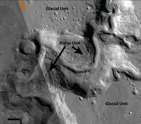
Actually… there are! Here is an image further north along the Vallis. We can see that northern Auqakuh Vallis cuts through a ridge-containing unit, but in most of the surrounding area, the ridge-containing unit is capped by a unit with glacial morphology that hides the ridge unit from view:

Our current hypothesis: The ridge unit formed before or at the same time as the valleys were being cut. Afterwards, glaciers and ice sheets covered the area and deepened and widened the valleys. The glaciers covered the northern Auqakuh Vallis region and most of the terrain north of it, including the western part of the study region.
The next group of CTX images extends our search area to the east. This is the area where this type of polygonal ridges were first mapped, before we had CTX images covering the entire area like we do now. The first mapping project (in 2006) identified ridge lattices inside mostly inside craters, leading to the hypothesis that they were impact-related breccia dikes. The second project (in 2013) mapped ridges along the Nili Fossae trough system, leading those scientists to hypothesize that the original fractures may be related to the trough system. Our study of the ridges to the west has been offering an expanded context for these hypotheses. The other special thing about this region is that we will be covering two of the three remaining potential landing sites for the next NASA Mars rover, called “Mars 2020”. Mars 2020 is carrying a suite of instruments that it will use to search for habitable places on Mars as well as organic material. The new rover will also carry a drill that it will use to take samples of many different rocks and cache them in tubes for a future mission to bring back to Earth. Wouldn’t it be great if they could bring a bit of ridge back for us?

New Images on Planet Four: Ridges
We’ve got some good news for your weekend. We’ve got brand new images on Planet Four: Ridges, expanding further south and east of our original area. More area covered, gives more opportunities to find unknown polygonal ridges. The more ridges we find, the better statistics we will have when we compare to other orbiter data sets to see if ground water is the main source for how these ridges form. You can see where the search area is in comparison to our first data set below. The cyan show the footprints of the new CTX images on the site, the magenta are the footprints of the CTX images we had uploaded at launch. We thought the magenta area would take a year to search, so we’re thrilled that we can expand the search radius. Thanks for your time and your contributions. We really appreciated.

Generated using JMARS (https://jmars.asu.edu/). The magenta region shows the footprints of the CTX images previously searched The cyan area shows the new CTX data that has been uploaded to the Planet Four: Ridges site.

zoomed in view- Generated using JMARS (https://jmars.asu.edu/) The magenta region shows the footprints of the CTX images previously searched The cyan area shows the new CTX data that has been uploaded to the Planet Four: Ridges site.
We’ll have some more blog posts in the coming days and weeks to talk more about this new search region.
Dive in and search for polygonal ridges today at http://ridges.planetfour.org
Working on Preliminary Planet Four: Ridges Results
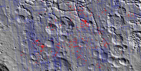
I’ve been working on getting some preliminary locations of polygonal ridges in the completed Planet Four: Ridges subject images. I thought I’d share. Here’s locations where 7 or more volunteers who reviewed a subject image and said there were ridges present. We have 10 people review each of the subject images on Planet Four: Ridges.
I’ve made some figures to show the locations of these subject images. Below are MOLA shaded elevation maps with the CTX images we searched outline in blue. The red boxes are the prelminary locations of polygonal ridges, based on the criteria discussed above,

And zoomed in more

We’ll use take these locations and eventually compare to the maps of minerals to further explore the formation mechanism for poylgonal ridges in the area. Stay tuned. More to come as we finish the next set of images live on the site. Help classify an image or two on Planet Four: Ridges today at http://ridges.planetfour.org
Sand Dunes in Arabia Terra
I wanted to point out some features you might have noticed in the Planet Four: Ridges images. Dark wiggly blobs as shown in the images below are actually sand dunes on Mars.


We’re showing images from orbit, but to give you a sense of what some of these might look like from the ground, here’s a selfie of Mars Curiosity at “Namib Dune”, part of the informally named Bagnold Dune Field located in Gale Crater. I learned recently that on Mars, sand dunes are black because they are made of ground up basaltic lava rocks, just like black sand beaches of Hawaii are.

Image credit: NASA/JPL-Caltech/MSSS
More Planet Four – Introducing Planet Four: Ridges
Today we have a guest blog by JPL research scientist Laura Kerber. Laura studies physical volcanology, aeolian geomorphology, wind over complex surfaces, and the ancient Martian climate,
The surface area of Mars is almost the same as the area of all of the continents on Earth. Only a tiny fraction of these vast, untouched lands have been explored by rovers. Of the rest, much of it has still never been seen up close by human eyes. Today we’ve launched Planet Four: Ridges, and we are asking for your help to explore a particularly interesting part of the Red Planet. The goal is to find polygonal ridge networks, which are intersecting lattices of thin ridges enclosing polygonal shapes.

A polygonal ridge network in the eastern Arabia Terra region of Mars. This image shows an area about 4 kilometers across
Some of these ridges can be up to 50 meters tall, and from the surface would appear like the ramparts of an enormous fortress. Networks of ridges are usually formed via the filling of fracture networks either with lava, wind-blown sediment, or mineral deposits from circulating ground waters. These fractures are then transformed into ridges as the softer units around them get eroded by the wind. Your classifications on this site will help researchers find these networks and compare them to distributions of other features, such as mineral signatures, ancient valley networks, and dried up lakes. The images you see here are taken using the mid-resolution (6 meter per pixel) Context Camera (CTX) in orbit around Mars. Each participant views portion of images and decides whether or not there is a polygonal ridge network in the frame. We collect together everyone’s views on each image and this helps us find new ridge networks to study. The ridge networks can be subtle, but human eyes are well suited for pattern-finding, which is why we rely on you over computer algorithms.
More than 3.5 billion years ago, the climate of Mars was much different than it is today. The surface of Mars shows evidence for hundreds of lakes, and thousands of kilometers of flowing rivers. During this time and earlier, warm groundwater may have circulated in the Martian subsurface, potentially providing a protected home for early Martian life. One piece of evidence for groundwater during this period is the presence of clays that are deep in the crust (often visible in the central peaks of impact craters). Another is the presence of mineral veins, which are formed when warm water carrying elements in solution deposits minerals on the walls of fractures. Hot water or steam can also alter wall rocks of fractures, causing the walls to harden compared with the surrounding material. Later, after the crack cools, the minerals become harder than the rock types that surround them, so that as the surrounding unit get eroded by the wind, what was originally a fracture becomes a ridge.

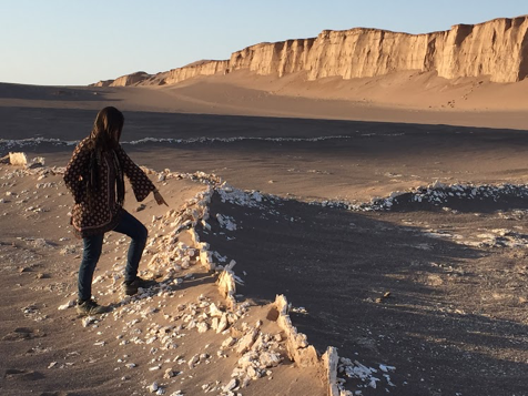
A ridge network filled with the mineral gypsum located in the Lut Desert of Iran, one of the world’s hottest and most lifeless deserts

A close-up of a Lut Desert gypsum ridge
Not all polygonal ridge networks are formed due to circulating groundwater, however. Sometimes open cracks on the surface get filled with windblown dust and sand, and that part gets preserved. Lava can also fill up cracks, either as it rises through the subsurface as magma, or if it is flowing along and drips into a fracture network. Finding all of the ridge networks on Mars helps us untangle which networks were formed by which process, all the while learning more about the intriguing wetter period in Mars’ history. This project focuses on the Eastern Arabia Terra region of Mars, where several ridge networks suggestive of mineral veins have been found.

A crack that has been hardened by hot steam escaping. It has since been brought into relief by the erosion of the surrounding rock. Campo de Piedra Pomez, Argentina.
As the project continues, we hope to share more background information on these interesting features here on this blog. Meanwhile, why not go find some ridge networks? Visit http://ridges.planetfour.org to start looking.


