
The Sun is back!
Animated markings
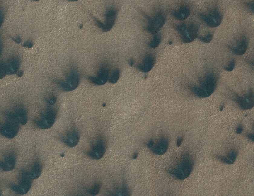
After the first day of our currently ongoing workshop for Citizen Science I have reached my personal goal for the day and created a tool to display an animated version for all the marked blotches of a PlanetFour image.
Here’s the result:
More to come in the upcoming days.
Dry ice snowfall
About a week ago our colleague and a resident polar scientist on the Mars Climate Sounder (MCS) science team Dr. Paul Hayne wrote this Planetary society blog post. He talks about CO2 snowing on Mars! If you are interested to know why we think that it snows dry ice on Mars or what shape CO2 snowflakes are, go check it out! And let us know your thoughts on how it affects the areas that you are helping us to analyze!
Anya
New Link for the Live Chat
Some technical difficulties but we are live
Standing on the Surface
With the HiRISE images we show on Planet Four, you’re peering down at the Martian surface from above, seeing the fans and blotches that we want you to you mark. What would something like the image below look like from the ground if you were standing on the thawing carbon dioxide ice sheet during the Southern spring?
Well, if the geysers were actively lofting carbon dioxide gas and dust and dirt from below the ice cap up onto the surface and into the Martian air, you’d probably see something like the artist’s conception below.
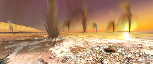
Artist’s rendition of geysers on the South Pole of Mars – Image credit; Arizona State University/Ron Miller
How high are the plumes? Current estimates suggest that the geysers and material it lofts stay relatively close to the ground going probably no higher than about 50-100m into the air according to previous estimates based on fan length and simple deposition models. Though more likely, the geysers achieve smaller heights than that most of the time. To try and directly measure the geyser plume heights, stereo imaging where Mars Reconnaissance Orbiter pointed at the same spot twice at different look angles has been used. The two resulting HiRISE images are then combined to give height information in much the same way our brains combine the images obtained from our eyes, each viewing at a slightly different angle and position than the other, to get depth perception. HiRISE would have been able to see the geyser plumes above the ground in the combined stereo pairs, if the majority achieved heights of 50-100 m, but no image to date yet has caught a detection of a plume. So that suggests that the geysers may not reach these maximum heights but instead only go up to maybe 5-10m off the ground.
Your clicks may be able to help constrain better the height of the geyser plumes. With your classifications, we will have the largest sample of fan lengths and directions and blotch radii ever measured on the Martian South Pole. With the fan lengths from your markings, a measure of the terrain’s slope, and an assumption for the particle size of the Martian dirt/dust being entrained by the escaping carbon dioxide gas, you can estimate the maximum height needed to loft the material for it to fall at a given distance from the geyser for a range of wind speeds.
to the North!
Hi there!
The PlanetFour so far has images only from Martian southern hemisphere. But northern polar areas also show a lot of activity and partially similar features! Have a look at this fresh video released by the JPL today. It shows fans, ice cracks and blotches similar to those that we are marking here, on Planet Four.
We are planning to add northern hemisphere images to this project too. Stay tuned!
Anya
You have asked!
Hi! I am a martian scientist and the member of Planet Four team. I am trying hard to answer many questions that you post in our forum. I notice that some questions come up more often than others, indicating what we have missed in our FAQs page.
I will try to post here about the topics that appear multiple times in the forum. And as first example, I want to tell you about one image that actually taught me something new. This one:
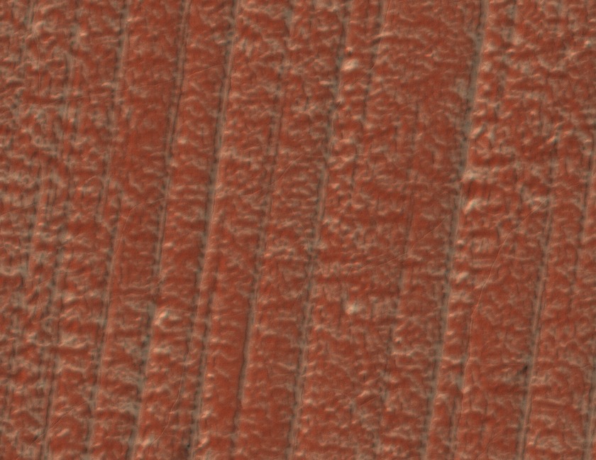
Many people asked, what are these parallel lines and how can so straight lines be of natural origin. First I thought that these are glacier marks. Until I realized that they are not depressions, but ridges. To clear up what they are I asked my colleague Mikhail Kreslavsky from University of California in Santa Cruz. He has much more experience in martian polar geology and glaciology than I do. This was his answer:
These are yardangs, traces of aeolian (that is wind-related) erosion. They are long parallel ridges. They form when wind removes soft, friable material and are oriented along the direction of the strongest winds. Yardangs are known in deserts on the Earth and are abundant on Mars. In this particular place, yardangs are remarkably regular, long, parallel. This fascinating regularity is probably caused by coincidence of two things. First, the material here is very homogeneous; it is slightly cemented dust; there are no embedded boulders, etc. This is the material of the South polar layered deposits, it was deposited from the atmosphere as a mixture of snow, frost and dust under different climate conditions in the past. Recently (geologically recently, hundreds of thousands of years) ice (former snow and frost) sublimated (evaporated) from the near-surface layer of this material, and the remaining slightly cemented dust is friable and homogeneous. Second, the strongest winds in this place are very stable. The polar layered deposits have a general shape of a ~700 km wide ~3 km high dome. The strongest winds here are so-called katabatic winds made by flow of cold (=dense) air from the pole on top of the dome downhill. People who have been to Antarctica or Greenland know katabatic winds very well. Because katabatic winds are controlled by slopes, they are much more stable than winds controlled by weather phenomena. The direction of the spring-time fans in this region often differs from the direction of the yardangs, because spring-time winds are not those strongest winds that shape the surface.
I hope, similar to me, you also enjoyed getting to know something new about Martian geology today.
Dig in for more!
Anya
Welcome to Planet Four
…well not literally. You’re still on Earth – don’t worry.
