
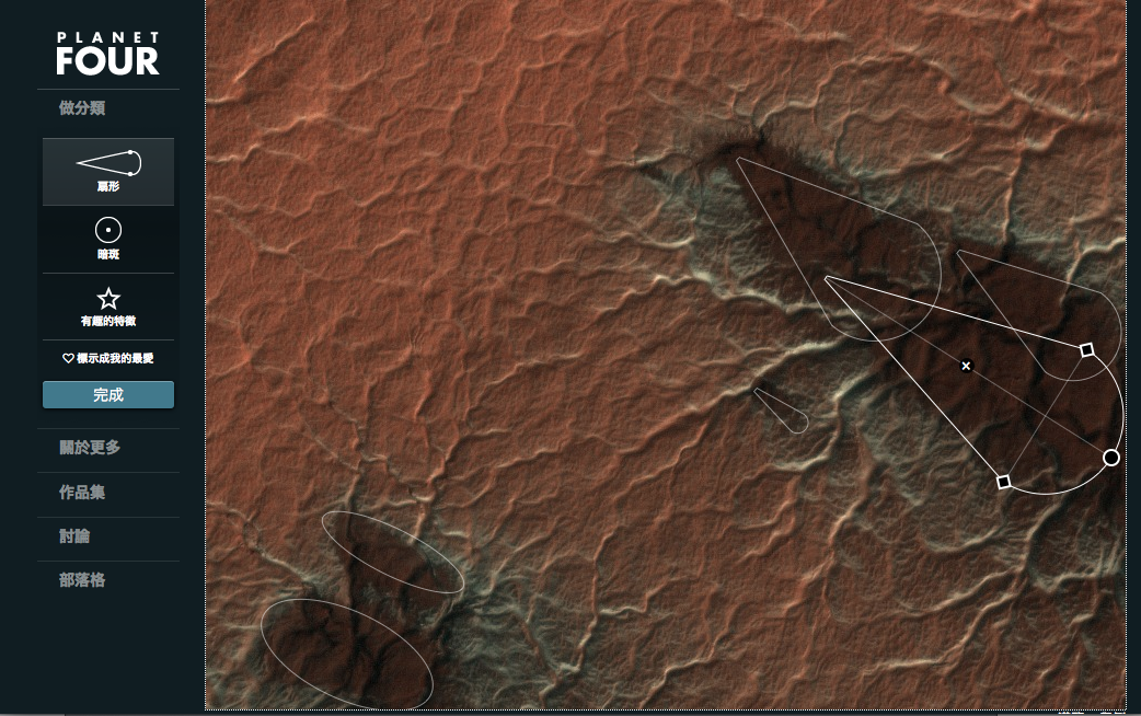
Animated markings
After the first day of our currently ongoing workshop for Citizen Science I have reached my personal goal for the day and created a tool to display an animated version for all the marked blotches of a PlanetFour image.
Here’s the result:
More to come in the upcoming days.
Planet Four Now Available In Traditional Character Chinese

歡迎光臨第四行星!We’re pleased to announce that Planet Four has been translated to traditional character Chinese thanks to the Education and Public Outreach (EPO) office at Academia Sinica’s Institute of Astronomy & Astrophysics (ASIAA). A big thank you to Lauren Huang for translating and Mei-Yin Chou for verifying the translation. I’m a postdoctoral fellow at ASIAA and Lauren, Mei-Yin, and I will be introducing Planet Four and the new translation to educators from around Taiwan at a teacher workshop on March 2nd as part of a larger workshop on Citizen Science in Astronomy hosted at ASIAA from March 3-7th. Michael and I will both be attending the full workshop as well.
Also many thanks to the Zooniverse’s Chris Snyder for getting all the technical things set up for the translation to go live on the site in time for the teacher workshop, and thank you to the Zooniverse’s Rob Simpson and Michael Parish for their help as well.
Are you interested in helping translate Planet Four into other languages? Find out more here.
What follows is the announcement from ASIAA, in English and then in traditional characte Chinese regarding the new Planet Four translation.
No rocketship required, help scientists study Mars from Earth
We need your help to explore Mars. On Planet Four (http://www.planetfour.org/?lang=zh_tw), you will be shown images of the South Pole of Mars taken by the HiRISE camera aboard the Mars Reconnaissance Orbiter. We are asking you to mark dark fans and dark blotches that appear and disappear during the Spring and Summer on the South Pole of Mars. During the winter carbon dioxide (CO2) condenses from the atmosphere onto the ground and forms the seasonal ice sheet. The ice begins to sublimate in the spring, and the seasonal cap retreats. The dark fans and blotches begin to appear in the Southern spring when the ice cap begins to thaw and sublimate back into the atmosphere. The fans and blotches then disappear at the end of the summer when there is no more ice left.
We want to study how these fans form, how they repeat from Spring to Spring and also what they tell us about the surface winds on the South Pole. If the fans are places where the wind is blowing, then they tell us the direction and the strength of the wind. Blotches then tell us where there is no wind. This is a task that computers cannot do, but which humans are really good at. We need to collect together many people’s markings and combine the results to be able identify the fans and blotches in the HiRISE. With your help mapping the seasonal fans and blotches, we can better study and understand the Martian climate. Explore Mars today at http://www.planetfour.org/?lang=zh_tw!
(Below is Lauren, the translator, wrote to share her excitement: )
As planetary scientists delight in seeing their probes launched into space, now that the Chinese translation of the Planet Four website is finished, we are also excited for more new volunteers from our own country are about to join this project! Either by way of a probe or a newly added translated language, the two things is similar: opening up a gate to a new world always makes us feel great!
Meg asked me to say a few things as to “why I translate the website for Planet Four”. Of course, the number one motive is serving the community! During the translating process, I constantly thought about the participants of zooniverse, that they are voluntarily doing this, offering their time and resource to support science research; it is our duty to put things in clear Chinese with correct science, so that our helpers can enjoy their science quests with pleasure. However, this task is not easy and is impossible if without my colleague’s help! I’d like to thank Dr. Mei-Yin Chou greatly, who helped verifying each paragraph throughout the site.
Chinese proverb says “one step back, a broaden sky” (退一步海闊天空). I guess whenever people have the time to log in this Planet Four website, it could be a time set aside as a retreat designated of Mars exploration. We are all curious to know more about the fourth planet of our solar system and can’t wait to see how the wind blows there! Have fun!
Help planetary scientists study the climate of Mars at http://planetfour.org/?lang=zh_tw
科學家找你幫幫忙:研究火星氣候不用火箭,立馬就上!
左鄰拉右舍,樓上牽樓下,探索火星氣候需要大家作伙來幫忙。如果你還沒聽說的話,第四行星網站(http://planetfour.org/?lang=zh_tw)是個需要靠人來幫忙辨識圖像的地方,這個網站會顯示一些火星南極圖像給你──這些照片都是由裝在火星偵察軌道機上的HiRISE照相機從火星南極現場拍回來的。按電腦程式出題,網站會請分類員對黑色暗斑和扇形圖像做出標示。這些圖像春季出現、夏季消失,地點是在火星南極。冬季時,火星大氣中的二氧化碳(CO2)會在地面上結凍,形成季節性冰席(ice sheet)。當春季來臨,火星南極的冰冠開始融化,昇華到大氣,到盛夏所有冰層都融化的時候,這些黑色扇形物跟斑點就全部消失了。
第四行星計畫想研究的是這些扇形如何形成,如何年復一年地循環著春夏秋冬四季,並認識南極地表的風。暗斑代表無風,而如果有風在吹則會形成扇形,我們能依此知道風的方向和強度。這項任務特徵是,電腦做不來,但人類卻能輕鬆做到,所以只要將很多人的標示結果集中結合在一起,就能辨識出HiRISE取回影像中那裡有扇形和暗斑。如此,按季節頻頻出現的扇形和暗斑,在你的協助下,就能協助我們更清楚了解火星氣候。啟程探索火星,不用火箭,今天就可以出發:http://www.planetfour.org?lang=zh_tw
(以下是中文版譯者黃珞文簡單心得分享:)
就像行星科學家因衛星發射而心情歡欣雀躍,我們完成了第四行星中文網站,也因將有一大群新分類員加入本計畫而令人充滿期待;衛星飛越太空,翻譯的人橋接了語言之隔,總之,一個美麗新世界即將亮相!
Meg要我講下翻譯的部分,我們在翻譯過程中最關心的是使用者需求,因為我想到宇宙動物園網站使用者都是自願的義務分類員,在閒暇之餘貢獻自己的資源來協助科學計畫達成目標,所以,能不能讓這群使用者在中文環境下、盡量負擔較小又輕鬆愉快地達成任務呢?感謝周美吟博士的幫忙,在易讀和科學正確這兩項指標上她都幫了大忙!不過如果有哪裡錯誤,還請跟我們說喔!
中國人說「退一步海闊天空」,天是無限想像飛馳的去處,無論平常的身分是什麼,若是有時間登入這個網站時,邀請大家能懷著「即將成為千萬公民科學參與者之一」的寬闊,也帶著些許好奇,一同來鑑識看看這太陽系的第四顆行星上,風會怎麼吹!祝旅途愉快!
天文學家請你幫幫忙!了解火星氣候,今天就上:http://www.planetfour.org?lang=zh_tw
All hail the Zooniverse
All hail the Zooniverse! The Zooniverse is the largest collection of online citizen science projects (which includes Planet Four) and as of Friday, the Zooniverse is now 1 million people strong!

Image Credit: Zooniverse
Congratulations to everyone involved on reaching this milestone! In just a single year, Planet Four represents over 40,000 of the 1 million registered Zooniverse volunteers. (This number just represents the logged-in volunteers. Over 100,000 people have participated in Planet Four to date). Check out the global map of the Zoonvierse community (made by Rob Simpson) to see where all the registered volunteers (including Planet Four participants) come from. If you don’t have a Zooniverse account, you can sign up today.
To give some history, the Zooniverse started back in 2007 with the launch of Galaxy Zoo to study galaxy morphology. It turns out that human beings are the best beating computers at determining whether a galaxy is a spiral or an elliptical or if the galaxy hosts a bar at its center or not. 7 years later, Galaxy Zoo is in its 4th iteration and the Zooniverse now hosts over 20 online citizen science projects which have contributed to date in total over 50 scientific publications. You can see how the Zooniverse has evolved over time in this blog post by the Daily Zooniverse. Although the Zooniverse started in astronomy, it now spans a wide range of fields including projects determining if whales have accents and transcribing World War 2 diaries.
Congratulations to everyone involved in the Planet Four community and thank you for the clicks. We couldn’t do the science without your contributions and your time. The Planet Four science team is working hard to use your classifications to understand the seasonal processes on the South Pole of Mars. Stay tuned to the blog for updates on our progress over the coming weeks and months.
Keep your fan and blotch mappings in Manhattan coming at http://www.planetfour.org and don’t forget to check out all the Zooniverse projects at http://www.zooniverse.org
Grab your 3-D glasses
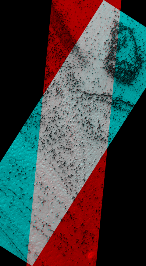
Image Credit: NASA/JPL/University of Arizona
http://www.uahirise.org/anaglyph/singula.php?ID=ESP_011351_0945
For orbiting spacecraft a trick with spacecraft orientation can be used to get 3-D information on the terrain of a planetary body. If images of the same region are taken at different angles, these images (usually taken as two images called stereo pairs) can be combined to make stereo or 3-D images. This is the same technique our brain uses to generate depth perception. This is because our eyes are spaced apart, each eye has a slightly different view of the things in front of us. Our brains automatically combine the information from the two images to gauge the distances to and construct the sizes of objects in our vision.
The HiRISE team does this by commanding the Mars Reconnaissance Orbiter to point such that the HiRISE camera rolls either left or right of the ground track of the spacecraft as its above a target region. This technique has been used to created digital terrain and elevation models of the landing sites for the Mars rovers and other areas of interest on Mars. Anya from the Planet Four team is working on analyzing a stereo pair of the spiders as she mentioned in one of our previous live chats.
A popular way to view a stereo pair from orbiting spacecraft is in what is called a stereo anaglyph where the images are combined such that there is one image for the left eye and one image for the right eye. The left looking image is displayed in red and the right looking image is displayed in blue. If you have a pair of red-blue 3-D glasses, you should see the the above image in 3-D.
I happened to come across an analgyph (the image above) of the seasonal fans taken during the monitoring of the South Pole in Season 2, and I thought I’d share. The full resolution 3-D image can be downloaded from here , and you explore the full-res image with zooming and scrolling capability with the HiView tool. Grab your 3-D glasses and enjoy!
Dry ice snowfall
About a week ago our colleague and a resident polar scientist on the Mars Climate Sounder (MCS) science team Dr. Paul Hayne wrote this Planetary society blog post. He talks about CO2 snowing on Mars! If you are interested to know why we think that it snows dry ice on Mars or what shape CO2 snowflakes are, go check it out! And let us know your thoughts on how it affects the areas that you are helping us to analyze!
Anya
The “Manhattan” region on Mars
We have now switched the data shown in Planet Four to focus on the Manhattan region, because it takes us quite a while to finish an area. (Everybody, keep clicking! Invite all your family and friends!)
Manhattan is a region within the ‘‘cryptic” terrain of the south pole of Mars. This terrain has been termed ‘‘cryptic” because even so its albedo (‘albedo’ measures the percentage of light reflected on a surface) darkens in the spring, indicating a better absorption of energy or even an absence of otherwise highly reflective ice, this terrain retains the 145 K temperature of CO2 ice until late in the season. This terrain is known to contain a host of phenomena that are inferred to arise from local gas jet activity.
The position of the Manhattan area within this cryptic terrain is indicated in the map below. Inca City by the way is such an interesting region because it shows all kinds of CO2 ice related activity while NOT being inside the cryptic region! Once we have finished Manhattan, we will switch to finish Inca City.
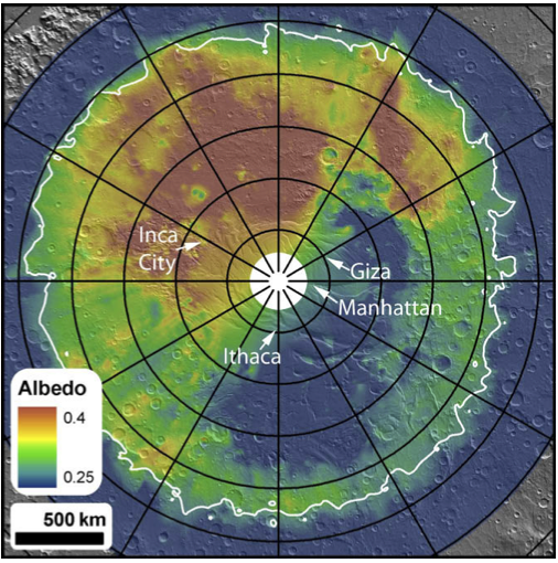
Cryptic region on the south pole of Mars. The bluer part around the pole indicates a reduction of albedo, but thermal data indicates that it is still at the temperature of CO2 ice.
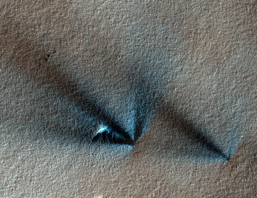
The Manhattan area shows wide-spread fan activity on both smoother and more rougher terrain. An example is shown below.
Fans in the Manhattan region of the south pole of Mars
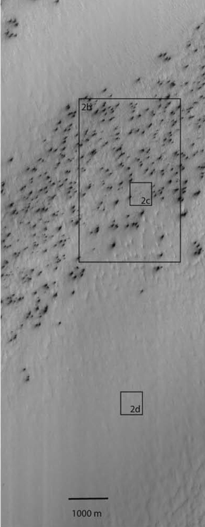
When zooming in on an area without clear fan activity, as shown below in the zoom-in on area 2d, one discovers channels or troughs similar looking to the arms of the spider-shaped araneiform structures, but with one essential difference: They are not centralized, like the ones from araneiforms, where a set of arms meet in a more or less pronounced center. This pattern of troughs without center features has been dubbed ‘lace’ due to its visual apprearance.
Studying the fan activity in these areas with these underlying and neighboring roughness patterns will tell us if the fans develop differently in any way, either in resulting size distributions or over time. This hopefully will provide clues on differences in ground stability and therefore different gas transport ability during the CO2 activity, which can be compared with a araneiform-creation model.
Zoomed in on area 2d from above. A ”lace ” surface at the Manhattan region.
All images of these post have been taken from C.J. Hansen et al. / Icarus 205 (2010) 283–295
One Earth Year of Planet Four in Images
Planet Four’s 1st birthday is on Wednesday. To celebrate and thank you for all of your help, below are the 50 most popular images classified. We tallied the number of people who favorited each image we’ve shown in the past year, and those in the gallery below in order came up on top. Click below on any of the images to get a larger view and to get a slide show to peruse through the entire collection. If you’re interested in any particular image, you can find all the images in this Talk collection. Help us celebrate by mapping some fans and blotches today at http://www.planetfour.org


Happy Aphelion
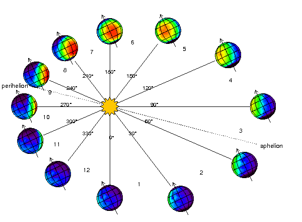
Today marks Mars’ passage through aphelion, its furthest point in its orbit from the Sun. At aphelion, Mars is moving slowest in its orbit while at perihelion, Mars is closest to the Sun and moving at its fastest velocity. Mars has a more eccentric or elliptical orbit than Earth, and has the second highest eccentricity out of the 8 planets in our Solar System.
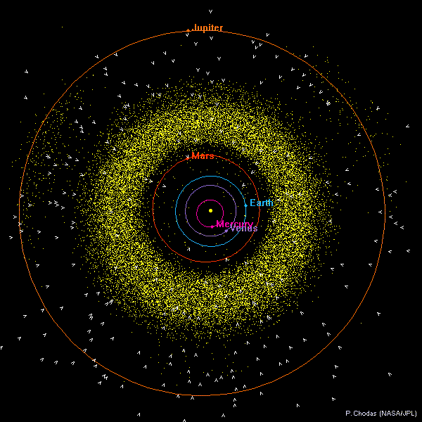
Plot of the inner solar system orbits (yellow dots are asteroid positions). You can see how eccentric Mars’ orbit is compared to the other inner Solar System planets – image Credit: JPL Solar System Dynamics/P. Chodas/ NASA/JPL http://ssd.jpl.nasa.gov/?ss_inner
The Red Planet’s orbital eccentricity may actually be an important factor in Mars’ climate. The Southern hemisphere right now is pointed away from the Sun and the carbon dioxide ice sheet is growing. Compared to the Northern hemisphere, Southern summers are shorter (because Mars is at perihelion during that time) and the solar insolation is more intense while the Southern winters are colder and longer. This dichotomy may be responsible for why seasonal fans and blotches are abundant during the thawing of the carbon dioxide ice sheet in Southern Spring and Summer, but fans and blotches are spotted far and in between in the same seasons in the Northern Hemisphere.
So far seasonal fans and blotches have mainly been spotted on the slopes of dunes at the Martian North Pole and tend to be smaller than their Southern hemisphere counterparts. One of the goals of Planet Four is to better study this. With your measurements of the frequencies, locations, and sizes of fans we’ll eventually compare Northern hemisphere fans to the occurrence and sizes of fans in the Southern hemisphere.
50 Years of the Deep Space Network
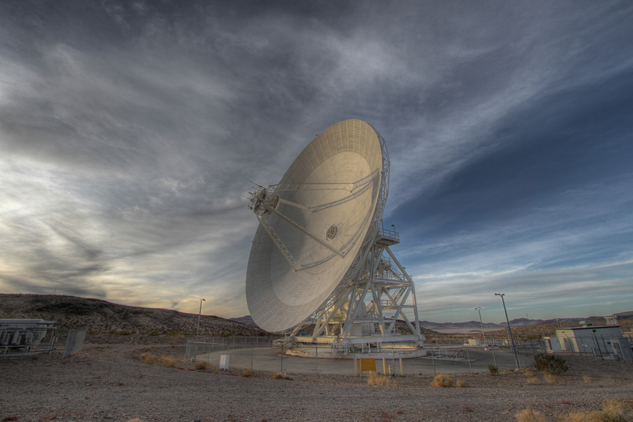
A Deep Space Network Antenna at the Goldstone Deep Space Communications Complex. Image Credit: NASA/JPL-Caltech
Tomorrow marks the 50th anniversary of the Deep Space Network, the array of radio dishes scattered around the globe tasked with communicating with NASA’s space missions orbiting the Earth and beyond. The Deep Space Network is crucial for sending commands to orbiting missions around Mars like the Mars Reconnaissance Orbiter, which is the home of the HiRISE camera that takes the images we show, and receiving the data these robot explorers take of our Solar System and the stars and galaxies beyond it.
Three stations were established so that there would always be at least one of the dish complexes on the Earth rotating into range for communications with a distant spacecraft. Today the Deep Space Network has dishes in Canberra, Australia; Madrid, Spain; and Goldstone, USA. The stations are separated by ~120 degrees of longitude.
In the Deep Space Network’s first year of operations, it communicated with just three spacecraft. In 1969, the Deep Space Station 46 (DSS46) in Australia captured the video sent of Neil Armstrong’s famous first Moon walk from the surface of Moon and relayed the video to the rest of the world. Fast forward 44 years to the present, and the Deep Space Network is now charged with supporting and communicating with over 30 space-based missions from NASA, ESA, JAXA, and ISRO. The Solar System has indeed become a busier and much explored place. The radio antennas are always on and talking with these multitude of robot explorers.
In honor of the tireless work of the Deep Space Network and its operators, let us all map some fans and blotches on the images taken from orbit around Mars that they have help provide us at http://www.planetfour.org.
Happy Birthday Deep Space Network, and whatever planet you are on, wishing you a Happy Holiday Season from all of us at Planet Four to you.
Aftermath of a Global Dust Storm
As we begin to approach winter in the northern hemisphere, so too does the southern hemisphere of our neighbouring planet, Mars. Set to experience its usual seasonal CO2 snowfall and lows of -125 degrees Celsius at the poles, it makes Earth seem pretty warm and cosy in comparison. This time of year sees the process of carbon dioxide beginning to ‘freeze-out’ at the southern pole, creating ice caps not unlike the ones that we are familiar with. Throughout the Martian year, the HiRISE instrument on board the Mars Reconnaissance Orbiter (MRO) captures images of the southern pole that the Planet Four community is helping to analyse. Between two seasons of imaging from the instrument a global dust storm swept across the red planet leaving a high concentration of fine grains in its atmosphere. The science team is eager to find out what effect, if any, such a large event could have on surface processes. By comparison of images previously analysed by the Planet Four community, this will hopefully lead to a better understanding of the different climate cycles and overall environment of Mars.
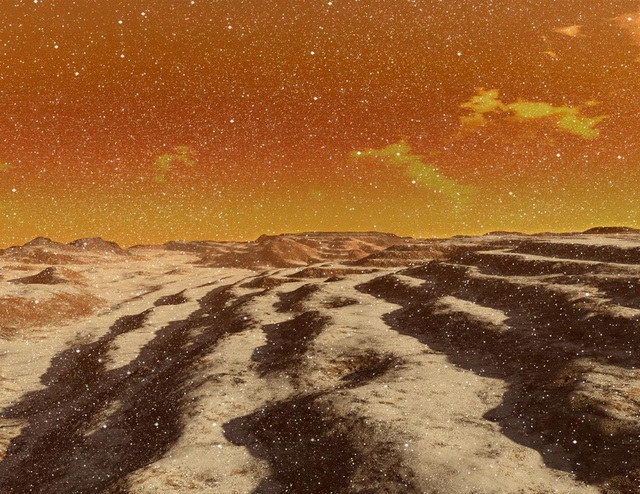
Snow storm on Mars. Image credit: Ron Miller
As you will already know, the main goal at Planet Four is to examine the size, frequency and distribution of material that bursts out from under the CO2 ice sheets as they begin to thaw in the warmer months. During the Martian spring at the southern pole, the caps start to receive more sunlight and the ice gradually sublimates back into the atmosphere. As there is no liquid phase of CO2, this means that when the ice heats it directly evolves into a gaseous state and returns into the atmosphere. Sunlight penetrates to the very bottom of the sheet, which causes the ice to transform into gas far below the surface. Since the gas is trapped and continues to form, the pressure eventually becomes high enough that it erupts through the sheet, bringing with it the underlying material which can be clearly distinguished on the surface. The sediment left behind from these geyser-like eruptions is what we analyse in the images in the form of ‘fans’ and ‘blotches’. If no wind is present the material falls straight back down under gravity and forms a blotch; where it is present, the material will be blown as it bursts out and we observe a fan shaped feature of material spanning out from its source.
Dust storms and dust devils could have an effect on this process, as the atmospheric and surface temperatures across the planet change depending on the amount of airborne material. The phenomena arise due to solar radiation heating the planet’s surface and causing convective currents which sweep up the finest grains of material into the atmosphere. As the wind interacts with suspended particles, the gusts intensify and encourage more dust into the air. If the wind rotates as it rises the speed and spin will increase, due to the conservation of angular momentum, and a dust devil is formed. Unlike the swirling bodies of sand seen on Earth, Martian devils can stand up to ten times as high and 50 times as wide due to the planet’s tenuous atmosphere and lower gravity. Most dust devils and dust storms form and dissipate within a matter of hours, but around one in every three Martian years sees a storm evolve and sweep across the whole globe, masking the surface in a dusty haze. Planet-wide dust storms are most likely to form at the equator in summer time when the most surface heating occurs and bigger temperature variations are present, before spreading across the globe. One such storm took place between periods of data acquisition by MRO; so how does this affect the images analysed by Planet Four?
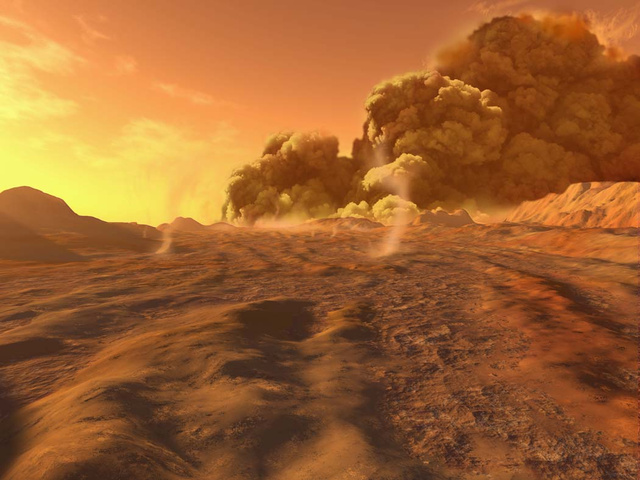
Dust storm on Mars. Image credit: Ron Miller
The global dust storm kicked up a lot of material into Mars’ thin atmosphere, where the finest grains can remain for a long period of time due to its cool and dry nature. This allowed more CO2 to condense onto the newly airborne dust, which later fell to settle and form ice sheets at the southern pole. The subsequently large amount of dust locked into the sheets following condensation will have affected the opacity of the ice, and therefore the amount of sunlight that heated its base in the spring. If less sunlight is able to penetrate the ice and heat the base layer, the whole process could have been delayed, causing eruptions to occur later in the year. As the fans and blotches are our only real indication of surface wind patterns on a large scale, whether the regions produce a similar network of marks or not is of great interest to the Planet Four team.
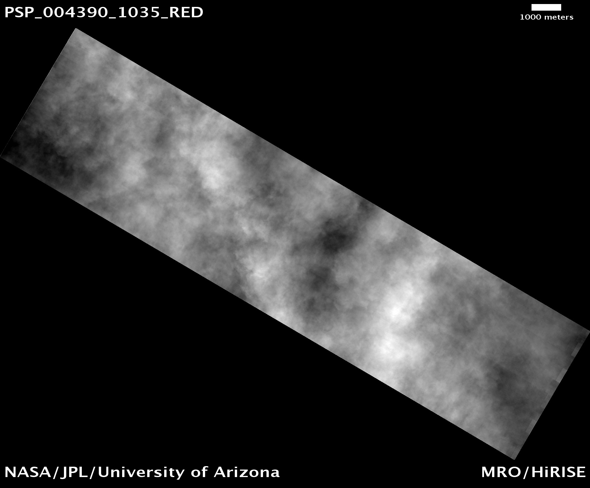
The storm took place in 2007, between seasons 1 and 2 of HiRISE imaging. The picture above captured the event, where the surface was completed obscured by the clouds of dust. Planet Four participants have already finished analysing images from seasons 2 and 3, and are currently working through those taken during season 1. It will therefore be very interesting to compare the nature of fans and blotches before the storm with the already processed images taken after the storm, as they may produce very different results.
Hopefully the data analysed will provide a clearer picture of how the two dominant cycles on Mars, dust and carbon dioxide, are interlinked. In turn, this should help to build our overall knowledge of the mysterious Martian climate. Please keep clicking and bring us closer to achieving this goal!
